Click on a photo to see the album.

Sunday, July 31, 2011


Sunday, July 24, 2011
Day 24 - Refuge Tagnarede to Banyuls-sur-Mer
24th July 2011
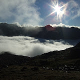
The final day! On the map this looked like a straightforward saunter down to Banyuls. But this morning I was greeted by a galeforce northerly wind as I stepped out from the shelter of Refuge de la Tagnarede. Being persistently battered by a freezing cold wind for the next few hours made the traverse to Pic Sailfort a bit of a battle.
However, as soon as I began the descent from Pic Sailfort the wind began to ease. It was strange bumping into a couple of French guys who'd just started that morning heading in the opposite direction along the GR10. They had a good month of adventures ahead of them, whereas in a few hours my journey would be over.
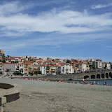
There is no great sense of satisfaction or pleasure at getting to the end of one of these big hikes, it's more a question of keeping focussed to the end to get the job done. When you arrive at Banyuls, nobody is interested that you've just hiked 800km from the Atlantic, so I just quietly sat by the beach for a few minutes before seeking out the train station to get away from the scorching heat and pink bodies frazzling themselves on the beach.
The biggest relief came when I arrived at the train station, bought my ticket to Girona and then slumped in the air-conditioned waiting room, knowing that I could finally relax.
View HRP - Day 24 in a larger map
 |
| HRP - Day 24 |
The final day! On the map this looked like a straightforward saunter down to Banyuls. But this morning I was greeted by a galeforce northerly wind as I stepped out from the shelter of Refuge de la Tagnarede. Being persistently battered by a freezing cold wind for the next few hours made the traverse to Pic Sailfort a bit of a battle.
However, as soon as I began the descent from Pic Sailfort the wind began to ease. It was strange bumping into a couple of French guys who'd just started that morning heading in the opposite direction along the GR10. They had a good month of adventures ahead of them, whereas in a few hours my journey would be over.
There is no great sense of satisfaction or pleasure at getting to the end of one of these big hikes, it's more a question of keeping focussed to the end to get the job done. When you arrive at Banyuls, nobody is interested that you've just hiked 800km from the Atlantic, so I just quietly sat by the beach for a few minutes before seeking out the train station to get away from the scorching heat and pink bodies frazzling themselves on the beach.
The biggest relief came when I arrived at the train station, bought my ticket to Girona and then slumped in the air-conditioned waiting room, knowing that I could finally relax.
View HRP - Day 24 in a larger map
Saturday, July 23, 2011
Day 23 - Moulin de la Palette to Refuge Tagnarede
23rd July 2011
I got up quietly to have a 6am breakfast with the Gite owner Laurent. There were a couple of other guys helping at the gite as part of the WWOOF project for developing organic farming. After a long leisurely breakfast, the other hikers were emerging. I managed to get going by 7am, but almost immediately reached a fork on the trail and took the wrong option. I should have taken the lefthand upper trail, but the lower track looked like the main route.
I followed this through a gate and up some switchbacks which I should have realised were heading the wrong way, when suddenly 2 dogs starting barking insanely and a guy came out of the farm I was trying to pass unnoticed. He looked at my map, and told me I was heading up the wrong hill. I tried to find my compass to confirm this, but he said a compass would be of now use. He told the only way to navigate these hills was to watch the sun, but then looked up and said "only there is no sun today". I thanked him as I turned around to head back down again, and he said "today I saved your life".
Soon I was back at the fork, and took the upper trail and found the small wooden sign pointing to "Roc de France" with blue marks. This was quite a fiddly trail that lead up to Col Cerda 1058m, which would have made a good camping spot. The trail then improved as it re-joined the GR10, but became quite fiddly again as I tried to follow the high ground over Roc de Frausa which had several rocky summits.
I took a short break once I reached the Refuge des Salines (briefly back in Spain), then followed forest tracks back to the border at Col de Lly for the short descent to Las Illas.
The section from Las Illas to Col du Perthus was mainly along forestry pistas, and with afternoon fatigue kicking in, it was quite hard to stay awake. It was after 4pm when I reached the grim border town of Le Perthus. This really is a place you want to get in and out of as quickly as possible. I grabbed a bagful of shopping from the first supermarket, and starting walking up the hill straightaway. The GR10 has recently be re-routed at this point to take you through rough scrubland, rather than hiking up the road. It would probably have been quicker to have walked up the road, since the marked trail took a pretty tortuous route.
For some reason my feet decided to be unbelievably sore again, so I needed to stop and take ibuprofen to be able to walk properly without hobbling. My plan at this point was to stop at the Refuge at Col de l'Ouillat, but when I reached it I wasn't in the mood for sitting with noisy people smoking and drinking, so I didn't even break step, but marched straight past and onwards and upwards towards Pic Neulos. By this stage I was far more comfortable in my own company, and preferred to by high on a windswept hill with shards of light breaking through the oppressively dark sky.
It was quite exhilarating to be right at the summit of Pic Neulos in fading light, and in a blasting wind, and knowing that the only shelter was the unmanned bothy Refuge de la Tagnarede in another kilometre or so. I reached the bothy just before 9.30pm, and luckily the place was deserted. All night the wind slammed and rattled the roof, which gave the place a spooky atmosphere.
View HRP - Day 23 in a larger map
 |
| HRP - Day 23 |
I got up quietly to have a 6am breakfast with the Gite owner Laurent. There were a couple of other guys helping at the gite as part of the WWOOF project for developing organic farming. After a long leisurely breakfast, the other hikers were emerging. I managed to get going by 7am, but almost immediately reached a fork on the trail and took the wrong option. I should have taken the lefthand upper trail, but the lower track looked like the main route.
I followed this through a gate and up some switchbacks which I should have realised were heading the wrong way, when suddenly 2 dogs starting barking insanely and a guy came out of the farm I was trying to pass unnoticed. He looked at my map, and told me I was heading up the wrong hill. I tried to find my compass to confirm this, but he said a compass would be of now use. He told the only way to navigate these hills was to watch the sun, but then looked up and said "only there is no sun today". I thanked him as I turned around to head back down again, and he said "today I saved your life".
Soon I was back at the fork, and took the upper trail and found the small wooden sign pointing to "Roc de France" with blue marks. This was quite a fiddly trail that lead up to Col Cerda 1058m, which would have made a good camping spot. The trail then improved as it re-joined the GR10, but became quite fiddly again as I tried to follow the high ground over Roc de Frausa which had several rocky summits.
I took a short break once I reached the Refuge des Salines (briefly back in Spain), then followed forest tracks back to the border at Col de Lly for the short descent to Las Illas.
The section from Las Illas to Col du Perthus was mainly along forestry pistas, and with afternoon fatigue kicking in, it was quite hard to stay awake. It was after 4pm when I reached the grim border town of Le Perthus. This really is a place you want to get in and out of as quickly as possible. I grabbed a bagful of shopping from the first supermarket, and starting walking up the hill straightaway. The GR10 has recently be re-routed at this point to take you through rough scrubland, rather than hiking up the road. It would probably have been quicker to have walked up the road, since the marked trail took a pretty tortuous route.
For some reason my feet decided to be unbelievably sore again, so I needed to stop and take ibuprofen to be able to walk properly without hobbling. My plan at this point was to stop at the Refuge at Col de l'Ouillat, but when I reached it I wasn't in the mood for sitting with noisy people smoking and drinking, so I didn't even break step, but marched straight past and onwards and upwards towards Pic Neulos. By this stage I was far more comfortable in my own company, and preferred to by high on a windswept hill with shards of light breaking through the oppressively dark sky.
It was quite exhilarating to be right at the summit of Pic Neulos in fading light, and in a blasting wind, and knowing that the only shelter was the unmanned bothy Refuge de la Tagnarede in another kilometre or so. I reached the bothy just before 9.30pm, and luckily the place was deserted. All night the wind slammed and rattled the roof, which gave the place a spooky atmosphere.
View HRP - Day 23 in a larger map
Friday, July 22, 2011
Day 22 - Prat Cabrera to Gite Moulin de la Palette
22nd July 2011
Once again, up and away before daybreak to begin the long traverse around Pic du Canigou on the so-called 'Balcon du Canigou'. I started off my headtorch along the narrow greasy path. Within minutes my feet were sodden from dew-laden grass overhanging the trail.
After a couple of hours I suddenly arrived at the Maison Forestiere de l'Estanyol, where I took a break for a minutes from the cold misty dampness to sit inside. I then pushed on for another couple of hours to arrive at Gite Mines de Batere, quite tired and with sore wet feet. Once inside, the place had a lovely mellow atmosphere with quiet gentle music and a wood fire burning. A stayed for several cafe au laits before venturing back out into the dreich mist.
The descent to Arles-sur-Tech was fairly confusing down woodland trails, and more complex than it appeared on the map. I imagine this section is normally descending into scorching heat, but today it was pretty grey and overcast. I arrived in Arles just after 2pm, but the Spar supermarche was closed until 3pm, so had a few minutes to re-group, dispose of rubbish, re-tape toes etc.
The climb beyond Arles was back into dense forest that completely throws your sense of direction. I did have a vague plan to bivvy high on the Roc de Frausa, but when I arrived at Gite Moulin de la Palette just after 6pm, the place had such a nice welcoming atmosphere I immediately decided to stay. Plus it meant I could have my first shower and shave for quite a while to feel a bit more human again.
The evening turned out to be an enjoyable social affair, with 2 big tables for the evening meal followed by French-style guitar playing and singing.
View HRP - Day 22 in a larger map
 |
| HRP - Day 22 |
Once again, up and away before daybreak to begin the long traverse around Pic du Canigou on the so-called 'Balcon du Canigou'. I started off my headtorch along the narrow greasy path. Within minutes my feet were sodden from dew-laden grass overhanging the trail.
After a couple of hours I suddenly arrived at the Maison Forestiere de l'Estanyol, where I took a break for a minutes from the cold misty dampness to sit inside. I then pushed on for another couple of hours to arrive at Gite Mines de Batere, quite tired and with sore wet feet. Once inside, the place had a lovely mellow atmosphere with quiet gentle music and a wood fire burning. A stayed for several cafe au laits before venturing back out into the dreich mist.
The descent to Arles-sur-Tech was fairly confusing down woodland trails, and more complex than it appeared on the map. I imagine this section is normally descending into scorching heat, but today it was pretty grey and overcast. I arrived in Arles just after 2pm, but the Spar supermarche was closed until 3pm, so had a few minutes to re-group, dispose of rubbish, re-tape toes etc.
The climb beyond Arles was back into dense forest that completely throws your sense of direction. I did have a vague plan to bivvy high on the Roc de Frausa, but when I arrived at Gite Moulin de la Palette just after 6pm, the place had such a nice welcoming atmosphere I immediately decided to stay. Plus it meant I could have my first shower and shave for quite a while to feel a bit more human again.
The evening turned out to be an enjoyable social affair, with 2 big tables for the evening meal followed by French-style guitar playing and singing.
View HRP - Day 22 in a larger map
Thursday, July 21, 2011
Day 21 - Refuge Ulldeter to Prat Cabrera
21st July 2011
This morning I was up and away by 6am, keen to capitalise on the ground I made up yesterday, and with half a mind on reaching Gite Mines de Batere.
I saw a fantastic sunrise from the Col de la Marrana before dropping down to Refuge Ulldeter for some breakfast. The next long ridge section to Refuge de Mariailles looked pretty straightforward on the map, but turned out to be much tougher than expected, so I was fairly tired by the time I reached Marialles and stopped for half an hour of so for an omelette and some coffee.
It was super-misty as I left the refuge and very murky on the climb up Pic du Canigou. The final steep section was quite daunting in the cold windy conditions, with no view whatsoever from the deserted summit. I descended quite carefully down the rocky zig-zags that eventually lead out to Refuge des Cortalets.
The atmosphere around the refuge was so depressing with cold dank mist and water dripping off the trees, it did not appeal, and even though it was about to get dark, I still decided to hike on down the trail for an hour or so to find a solitary camping spot.
I reached the junction at Prat Cabrera where the narrow rocky 'Balcon du Canigou' footpath begins. This looked like a bad choice for camping spots, but managed to find a lumpy patch of level ground just below the junction, in tussocky wet grass that did the job.
View HRP - Day 21 in a larger map
 |
| HRP - Day 21 |
This morning I was up and away by 6am, keen to capitalise on the ground I made up yesterday, and with half a mind on reaching Gite Mines de Batere.
I saw a fantastic sunrise from the Col de la Marrana before dropping down to Refuge Ulldeter for some breakfast. The next long ridge section to Refuge de Mariailles looked pretty straightforward on the map, but turned out to be much tougher than expected, so I was fairly tired by the time I reached Marialles and stopped for half an hour of so for an omelette and some coffee.
It was super-misty as I left the refuge and very murky on the climb up Pic du Canigou. The final steep section was quite daunting in the cold windy conditions, with no view whatsoever from the deserted summit. I descended quite carefully down the rocky zig-zags that eventually lead out to Refuge des Cortalets.
The atmosphere around the refuge was so depressing with cold dank mist and water dripping off the trees, it did not appeal, and even though it was about to get dark, I still decided to hike on down the trail for an hour or so to find a solitary camping spot.
I reached the junction at Prat Cabrera where the narrow rocky 'Balcon du Canigou' footpath begins. This looked like a bad choice for camping spots, but managed to find a lumpy patch of level ground just below the junction, in tussocky wet grass that did the job.
View HRP - Day 21 in a larger map
Wednesday, July 20, 2011
Day 20 - Refuge des Besines to Refuge Ulldeter (almost)
20th July 2011
After a rather short 'recovery' day yesterday, I knew I had some catching up to do today. It is always more difficult to make an early start from a refuge, but I was away by 6:50am.
I had no intention of climbing Pic Carlit, so took the easier GR10 alternative to reach the Barrage des Bouillouses. A fantastically scenic and popular spot.
Next came a long section of trails through forest, where I was almost asleep on my feet, head nodding and walking like a drunkard. I just about maintained consciousness to arrive at Bolquere where my plan was to do a quick shop and then press on towards the hills beyond Eyne. However this plan was scuppered when I reached the shop at 2.15pm only to discover it wouldn't re-open until 4pm. My only option now was to visit the next door hotel, grab a decent meal and relax for the next 1.5 hours. Once the shop was open again, I bought a few more provisions then followed the road all the way to Eyne.
Having lost a couple of hours, my initial plan was to camp somewhere near the head of the Vallee d'Eyne, however I was making such good time, and keen to use the full daylight hours, so just kept going up to Col de Nuria 2683m, and by the time I reached Pic de Noufonts 2861m, it was just after 8pm so I knew I had just over an hour's daylight to complete the traverse above Nuria and find somewhere to camp. This helped to focus the mind, and to get a bit of a move on.
Luckily the wands were out for the Olla de Núria Sky Race, which made the route finding a bit easier in the failing light. Plus this section is also on the GR11, so I vaguely recognised the route from last year. I managed to descend to about 2400m and find a patch of flat ground and was in the tent by 9.45pm.
View HRP - Day 20 in a larger map
 |
| HRP - Day 20 |
After a rather short 'recovery' day yesterday, I knew I had some catching up to do today. It is always more difficult to make an early start from a refuge, but I was away by 6:50am.
I had no intention of climbing Pic Carlit, so took the easier GR10 alternative to reach the Barrage des Bouillouses. A fantastically scenic and popular spot.
Next came a long section of trails through forest, where I was almost asleep on my feet, head nodding and walking like a drunkard. I just about maintained consciousness to arrive at Bolquere where my plan was to do a quick shop and then press on towards the hills beyond Eyne. However this plan was scuppered when I reached the shop at 2.15pm only to discover it wouldn't re-open until 4pm. My only option now was to visit the next door hotel, grab a decent meal and relax for the next 1.5 hours. Once the shop was open again, I bought a few more provisions then followed the road all the way to Eyne.
Having lost a couple of hours, my initial plan was to camp somewhere near the head of the Vallee d'Eyne, however I was making such good time, and keen to use the full daylight hours, so just kept going up to Col de Nuria 2683m, and by the time I reached Pic de Noufonts 2861m, it was just after 8pm so I knew I had just over an hour's daylight to complete the traverse above Nuria and find somewhere to camp. This helped to focus the mind, and to get a bit of a move on.
Luckily the wands were out for the Olla de Núria Sky Race, which made the route finding a bit easier in the failing light. Plus this section is also on the GR11, so I vaguely recognised the route from last year. I managed to descend to about 2400m and find a patch of flat ground and was in the tent by 9.45pm.
View HRP - Day 20 in a larger map
Tuesday, July 19, 2011
Day 19 - Camping d'Incles to Refuge des Besines
19th July 2011
Having been sick in the night, I was feeling apprehensive this morning. My mood was not helped at 6am by the fact it was still pitch dark, pouring with rain and a full-on thunder storm was raging. I couldn't muster the enthusiasm to leave the shelter of the tent just yet, so re-inflated my thermarest, got back in my sleeping bag, and went back to sleep for an hour to let the worst of the storm pass.
At 7am, the rain was lighter so I leapt out of the tent, stripped it down and started splish sploshing up the soggy trail into the mist. It got really quite cold, rainy and unpleasant as I approached the Refuge de Juclar. I expected to have the place to myself so was surprised when I walked in to find about 30 school kids all looking like they'd had one heck of a party the night before.
Once more into the mist and rain, and I was soon over the Port l'Albe to leave Andorra for France. The descent was super rough and rocky, and played havoc with my sore toes. I stopped at the first big lake to try to dry my sodden shoes and re-tape my toes which were in a terrible state. A group of 3 French hikers suddenly appeared and we had a bit of a chat, before I got a move on for the descent to l'Hospitalet.
I was expecting some sort of shop at l'Hospitalet, but there was nothing open apart from the Hotel du Puymorens. I made myself comfortable in the vestibule, and ordered coffees & croissants and tried to get my shoes dried out, and re-taped my toes. Soon the 3 French hikers who I'd seen earlier appeared. We had some more chat and all decided to walk to the Refuge des Besines later in the afternoon. I had planned to go a bit further, but without any food, the staffed refuge seemed a better option.
The hike to the refuge was on easy graded trails and took just under 2 hours at a fairly rapid pace. This gave plenty of time for dossing around and recovering and for eating the most enormous amount of food during the evening meal. A good social evening.
View HRP - Day 19 in a larger map
 |
| HRP - Day 19 |
Having been sick in the night, I was feeling apprehensive this morning. My mood was not helped at 6am by the fact it was still pitch dark, pouring with rain and a full-on thunder storm was raging. I couldn't muster the enthusiasm to leave the shelter of the tent just yet, so re-inflated my thermarest, got back in my sleeping bag, and went back to sleep for an hour to let the worst of the storm pass.
At 7am, the rain was lighter so I leapt out of the tent, stripped it down and started splish sploshing up the soggy trail into the mist. It got really quite cold, rainy and unpleasant as I approached the Refuge de Juclar. I expected to have the place to myself so was surprised when I walked in to find about 30 school kids all looking like they'd had one heck of a party the night before.
Once more into the mist and rain, and I was soon over the Port l'Albe to leave Andorra for France. The descent was super rough and rocky, and played havoc with my sore toes. I stopped at the first big lake to try to dry my sodden shoes and re-tape my toes which were in a terrible state. A group of 3 French hikers suddenly appeared and we had a bit of a chat, before I got a move on for the descent to l'Hospitalet.
I was expecting some sort of shop at l'Hospitalet, but there was nothing open apart from the Hotel du Puymorens. I made myself comfortable in the vestibule, and ordered coffees & croissants and tried to get my shoes dried out, and re-taped my toes. Soon the 3 French hikers who I'd seen earlier appeared. We had some more chat and all decided to walk to the Refuge des Besines later in the afternoon. I had planned to go a bit further, but without any food, the staffed refuge seemed a better option.
The hike to the refuge was on easy graded trails and took just under 2 hours at a fairly rapid pace. This gave plenty of time for dossing around and recovering and for eating the most enormous amount of food during the evening meal. A good social evening.
View HRP - Day 19 in a larger map
Monday, July 18, 2011
Day 18 - Pla de Boet to Camping d'Incles
18th July 2011
Once again I was up and away before daybreak. It was actually pretty cold this morning with frost on the ground as I hiked up to Port de Boet 2509m. I reached the pass just after sunrise, and was greeted with a stunning cloud inversion on the French side.
The descent was pretty rough as I descended into thick freezing fog to reach Etang de la Soucarrane. I was very glad I hadn't pressed on the night before, since this would have been a grim place to camp. The next section was more or less pathless and involved thrashing through tussocky wet grass and undergrowth to eventually pop out on a dirt road.
My shoes were now soaked and full of water, so I spent a few minutes wringing out my socks and trying to dry my shoes to some extent. It was much easier hiking now up to the Port de Rat 2540m which drops over into Andorra. Also the weather was brightening up, and there was an easy descent to La Coma bar/restaurant in El Serrat ski area. I took some time here to re-group and to dry my kit, taking over a couple of the tables.
It was still quite cold and windy despite the bright sunshine, but on the descent to El Serrat the temperature picked up, and for the first time in a few days it was actually warm and sunny. Before reaching El Serrat the road branches upwards and turns into a dirt track to reach Refugi de Sorteny. I stopped at the water point to re-fill, and to eat before pressing on through wonderful meadows full of alpine flowers.
The next section of trail lead easily to the Collada dels Meners 2713m, where I caught up with a Frenchman also hiking the HRP. We then hiked together as far as Cabana Coms de Jan, where he planned to stay the night. I thought I might be able to reach Refugi de Juclar, however the continuation trail had far more ascent than anticipated, so once I'd reached Cabana Sorda I decided to drop down into the valley to Camping d'Incles. This turned out to be a good plan as I found out later on.
Camping d'Incles was a grim and depressing spot with no facilities, but I found a small patch of grass good enough to pitch the tent. During the night I felt unwell and was sick, and was anxious that I'd got food poisoning.
View HRP - Day 18 in a larger map
 |
| HRP - Day 18 |
Once again I was up and away before daybreak. It was actually pretty cold this morning with frost on the ground as I hiked up to Port de Boet 2509m. I reached the pass just after sunrise, and was greeted with a stunning cloud inversion on the French side.
The descent was pretty rough as I descended into thick freezing fog to reach Etang de la Soucarrane. I was very glad I hadn't pressed on the night before, since this would have been a grim place to camp. The next section was more or less pathless and involved thrashing through tussocky wet grass and undergrowth to eventually pop out on a dirt road.
My shoes were now soaked and full of water, so I spent a few minutes wringing out my socks and trying to dry my shoes to some extent. It was much easier hiking now up to the Port de Rat 2540m which drops over into Andorra. Also the weather was brightening up, and there was an easy descent to La Coma bar/restaurant in El Serrat ski area. I took some time here to re-group and to dry my kit, taking over a couple of the tables.
It was still quite cold and windy despite the bright sunshine, but on the descent to El Serrat the temperature picked up, and for the first time in a few days it was actually warm and sunny. Before reaching El Serrat the road branches upwards and turns into a dirt track to reach Refugi de Sorteny. I stopped at the water point to re-fill, and to eat before pressing on through wonderful meadows full of alpine flowers.
The next section of trail lead easily to the Collada dels Meners 2713m, where I caught up with a Frenchman also hiking the HRP. We then hiked together as far as Cabana Coms de Jan, where he planned to stay the night. I thought I might be able to reach Refugi de Juclar, however the continuation trail had far more ascent than anticipated, so once I'd reached Cabana Sorda I decided to drop down into the valley to Camping d'Incles. This turned out to be a good plan as I found out later on.
Camping d'Incles was a grim and depressing spot with no facilities, but I found a small patch of grass good enough to pitch the tent. During the night I felt unwell and was sick, and was anxious that I'd got food poisoning.
View HRP - Day 18 in a larger map
Sunday, July 17, 2011
Day 17 - Graus to Pla de Boet
17th July 2011
Today I was up an away from the Graus campsite before daybreak, to re-join the HRP at Noarre by 7am. On the climb up to Coll de Certascan 2605m the weather wasn't looking too great, and I reached the Refugi de Certascan by 11am, just before it started absolutely chucking it down with rain.
It was quite comforting being inside sheltered from the elements, drinking coffee and having an early lunch. However I wasn't that keen about stepping outside again into the freezing pouring rain. Just after midday I braced myself to continue along the slippery rocky trail, in full waterproofs.
Luckily the rain soon eased, and I found a much better descent to Pla de Boavi than described in the guidebook. I simply followed red and white markers that dropped you into the valley a few hundred metres downstream of the large flat area occupied by schoolkids on a holiday camp.
My target for the afternoon was to see whether I could cross the Port de Boet back into France. The next section of trail was perfectly graded zig-zags through forest that made for rapid progress to the Coll de Sellente 2240m. The trail then got rougher past the Refugi de Cinquantenari, so it took a bit longer than expected to reach the Pla de Boet. It was now after 7pm, and I didn't fancy the 600m climb to Port de Boet so late in the day, so decided to camp at the furthest end of the Pla de Boet and enjoy the evening sunshine.
View HRP - Day 17 in a larger map
 |
| HRP - Day 17 |
Today I was up an away from the Graus campsite before daybreak, to re-join the HRP at Noarre by 7am. On the climb up to Coll de Certascan 2605m the weather wasn't looking too great, and I reached the Refugi de Certascan by 11am, just before it started absolutely chucking it down with rain.
It was quite comforting being inside sheltered from the elements, drinking coffee and having an early lunch. However I wasn't that keen about stepping outside again into the freezing pouring rain. Just after midday I braced myself to continue along the slippery rocky trail, in full waterproofs.
Luckily the rain soon eased, and I found a much better descent to Pla de Boavi than described in the guidebook. I simply followed red and white markers that dropped you into the valley a few hundred metres downstream of the large flat area occupied by schoolkids on a holiday camp.
My target for the afternoon was to see whether I could cross the Port de Boet back into France. The next section of trail was perfectly graded zig-zags through forest that made for rapid progress to the Coll de Sellente 2240m. The trail then got rougher past the Refugi de Cinquantenari, so it took a bit longer than expected to reach the Pla de Boet. It was now after 7pm, and I didn't fancy the 600m climb to Port de Boet so late in the day, so decided to camp at the furthest end of the Pla de Boet and enjoy the evening sunshine.
View HRP - Day 17 in a larger map
Saturday, July 16, 2011
Day 16 - Estany d'Airoto to Bordes de Graus
16th July 2011
I was keen to get away early to find some water, so my alarm was set for 5am. However when I was ready to leave at 5.40am it was still virtually pitch dark, so I delayed a few minutes before setting off by headtorch at first.
It was relief to descend from the Collada del Clot de Moredo to La Basseta to find a stream that was strangely disappearing straight into the hillside. I felt much better after a good drink, but then made a few bad route choices on the descent to Alos d'Isil and ended up taking the long way round on a rather tortuous dirt track. I took a good break at Alos d'Isil to eat and refill my water bottle.
After Alos d'Isil was pleasant section of road beside a sparkling river, before turning off for a steep wooded climb that eventually lead steeply to the Coll de la Cornella 2485m.
The following section to Refugi Enric Pujol was through rugged landscape scattered with mountain lakes. I stopped for a few minutes at the Refuge - the small metal box type - to chat with an English/New Zealand couple. When I mentioned how little food I was carrying, these suggested the detour to Bordes de Graus Camping. This seemed like quite an appealing option to get a proper meal. My orginal plan had been to continue to Noarre and beyond, but there was no way I could reach Refugi de Certascan today, so I decided to drop down to Graus.
The campsite was relaxing with good food, however it was the only time in the whole that I was really savaged by mosquitoes.
View HRP - Day 16 in a larger map
 |
| HRP - Day 16 |
I was keen to get away early to find some water, so my alarm was set for 5am. However when I was ready to leave at 5.40am it was still virtually pitch dark, so I delayed a few minutes before setting off by headtorch at first.
It was relief to descend from the Collada del Clot de Moredo to La Basseta to find a stream that was strangely disappearing straight into the hillside. I felt much better after a good drink, but then made a few bad route choices on the descent to Alos d'Isil and ended up taking the long way round on a rather tortuous dirt track. I took a good break at Alos d'Isil to eat and refill my water bottle.
After Alos d'Isil was pleasant section of road beside a sparkling river, before turning off for a steep wooded climb that eventually lead steeply to the Coll de la Cornella 2485m.
The following section to Refugi Enric Pujol was through rugged landscape scattered with mountain lakes. I stopped for a few minutes at the Refuge - the small metal box type - to chat with an English/New Zealand couple. When I mentioned how little food I was carrying, these suggested the detour to Bordes de Graus Camping. This seemed like quite an appealing option to get a proper meal. My orginal plan had been to continue to Noarre and beyond, but there was no way I could reach Refugi de Certascan today, so I decided to drop down to Graus.
The campsite was relaxing with good food, however it was the only time in the whole that I was really savaged by mosquitoes.
View HRP - Day 16 in a larger map
Friday, July 15, 2011
Day 15 - Estany deth Cap deth Port to Estany d'Airoto
15th July 2011
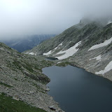
The next day, thankfully my ankle was OK... I was away from Estany deth Cap deth Port at daybreak, slightly nervous about reaching the Salardu shop before siesta. The initial section was on vaguely familiar terrain having hiked this during the GR11 last year. At Refuge Colomers I peeled off northwards at the dam to descend a nice broad valley. Luckily I reached Salardu at about 12.50pm with the shop closing at 1.15pm. I grabbed some food, and also bought some more strapping and ibuprofen at the pharmacy. Whilst re-packing I lost patience with lugging around the Kahtoola Microspikes, so left them behind under the bench.
I grabbed a quick plate of pasta before setting off on the afternoon shift. Initially the route appeared to be heading in completely the wrong direction, but in fact picked up a nice shaded trail through the woods before hitting dirt roads up to the vast skiiing area covered with grazing horses. The climb continued steadily past a few lakes until I suddenly bumped into Rick DeLong coming the other way. We had corresponded by email beforehand, so it was good to meet in person. Rick had already thru-hiked the PCT so knew all about travelling light, and had a pack way lighter than mine. We chatted for half an hour before heading our separate ways. I was a bit anxious now that it was getting late as I flogged steeply up Tuc Something. A pretty dramatic rocky summit. The continuation along the ridge was seriously rocky and slow-going.
I eventually reached the Coll d'Airoto and my plan was to drop to the Refuge d'Airoto which has a water source, but I made the mistake of trying to go around the lake on the north-eastern side which turned out to be an horrific boulder field that was wearing on the nerves and time-consuming. So I kind of ran out of time to get to the refuge and instead just wind-camped high above the lake on the first bit of flat ground I could find. This meant I had very little water for the night which wasn't ideal.
View HRP - Day 15 in a larger map
 |
| HRP - Day 15 |
The next day, thankfully my ankle was OK... I was away from Estany deth Cap deth Port at daybreak, slightly nervous about reaching the Salardu shop before siesta. The initial section was on vaguely familiar terrain having hiked this during the GR11 last year. At Refuge Colomers I peeled off northwards at the dam to descend a nice broad valley. Luckily I reached Salardu at about 12.50pm with the shop closing at 1.15pm. I grabbed some food, and also bought some more strapping and ibuprofen at the pharmacy. Whilst re-packing I lost patience with lugging around the Kahtoola Microspikes, so left them behind under the bench.
I grabbed a quick plate of pasta before setting off on the afternoon shift. Initially the route appeared to be heading in completely the wrong direction, but in fact picked up a nice shaded trail through the woods before hitting dirt roads up to the vast skiiing area covered with grazing horses. The climb continued steadily past a few lakes until I suddenly bumped into Rick DeLong coming the other way. We had corresponded by email beforehand, so it was good to meet in person. Rick had already thru-hiked the PCT so knew all about travelling light, and had a pack way lighter than mine. We chatted for half an hour before heading our separate ways. I was a bit anxious now that it was getting late as I flogged steeply up Tuc Something. A pretty dramatic rocky summit. The continuation along the ridge was seriously rocky and slow-going.
I eventually reached the Coll d'Airoto and my plan was to drop to the Refuge d'Airoto which has a water source, but I made the mistake of trying to go around the lake on the north-eastern side which turned out to be an horrific boulder field that was wearing on the nerves and time-consuming. So I kind of ran out of time to get to the refuge and instead just wind-camped high above the lake on the first bit of flat ground I could find. This meant I had very little water for the night which wasn't ideal.
View HRP - Day 15 in a larger map
Thursday, July 14, 2011
Day 14 - Hospital de Benasque to Estany deth Cap deth Port
14th July 2011
After my `rest day´ at Hospital de Benasque, it was time to get going again on 14th July. I met the Czech folk after about an hour before the climbing started up towards the Coll de Molleres. It was still pretty misty and dank and not easy to follow the route. Luckily just before the col, the mist suddenly enough to see where the col was. The descent down the other side was seriously steep to start with, but quickly backed off to a sea of boulders. The descent was so long and rough that after a while the tendons in my left ankle were screaming in complaint. Eventually I was scarcely moving and just hobbling along, so I needed to stop and tape my ankle.
When I reached the valley floor near Hospital de Vielha, I stuck my foot in the river for 15 minutes, and re-taped the ankle before continuing again. I chatted with a nice French couple who were about to hitch through the tunnel for supplies at Vielha, and they persuaded me to take some ibuprofen and carry on. So I began the next stage in reached the Restance Refuge pretty late, but just walked straight past and made a higher bivouac beside the Estany deth Cap deth Port.
View HRP - Day 14 in a larger map
 |
| HRP - Day 14 |
After my `rest day´ at Hospital de Benasque, it was time to get going again on 14th July. I met the Czech folk after about an hour before the climbing started up towards the Coll de Molleres. It was still pretty misty and dank and not easy to follow the route. Luckily just before the col, the mist suddenly enough to see where the col was. The descent down the other side was seriously steep to start with, but quickly backed off to a sea of boulders. The descent was so long and rough that after a while the tendons in my left ankle were screaming in complaint. Eventually I was scarcely moving and just hobbling along, so I needed to stop and tape my ankle.
When I reached the valley floor near Hospital de Vielha, I stuck my foot in the river for 15 minutes, and re-taped the ankle before continuing again. I chatted with a nice French couple who were about to hitch through the tunnel for supplies at Vielha, and they persuaded me to take some ibuprofen and carry on. So I began the next stage in reached the Restance Refuge pretty late, but just walked straight past and made a higher bivouac beside the Estany deth Cap deth Port.
View HRP - Day 14 in a larger map
Subscribe to:
Posts (Atom)